Monday, March 31, 2008

Do Not Enter - Crime Scene

...We interrupt our regular programming with this breaking news from the Pie-In-the-Sky newsroom. Here now is Talkinhead Hypespewer.

Talkinhead: We have a late breaking report of mob violence, mayhem! and possibly explosions and dead people!

We go now to Monroeton's Department of Motor Vehicles Driver Licencing Test Center and our reporter Dishy Dullfacts for details.


Live Pie-In-the-Sky Video of the Breaking Event!

Dishy Dullfacts: Thank you, Talkinhead, I am at the scene of the disturbance where you can clearly see, there is no one arou...

Talkinhead: Excuse me Dishy, we need to interrupt! We will be back with details of this tragedy after these words from our sponsors!

(6 or 7 commercials - with the most mindless one shown twice)

Talkinhead: For those of you just joining us (said in a tone of shock that someone wouldn't have already been watching) we have a report of mob violence in Monroeton!

To recap! Apparently a gang of five Orange Striped Barrels with heavy batons have senselessly and badly beaten another OSB whose condition at this time is not known! The reason for this vicious attack is not known! The angry gang of OSB's, who may or may not have been police officers, and the victim whose name is not known, are believed to be the cause of a serious traffic accident! Gosh, do we have another Rodney King thing happening here?! We go now to the scene where our reporter Dishy Dullfacts is standing by with a her report!


Live Pie-In-the-Sky Video of the Breaking Event!

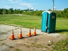
Dishy Dullfacts: ...As I was saying, I am at the Monroeton's Department of Motor Vehicles Driver Licencing Test Center, the scene of the disturbance where you can see, an OSB is on the ground.

Earlier today, an applicant taking their driver's test, was performing the parallel parking portion of the test and accidently knocked over an OSB. Obviously, they should have failed the test but probably did not.

I am told that the fallen OSB, simliar to those available from the local Highway Supply depot at a cost about $35,000, will be set upright again, possibly as soon as within a couple weeks. Live, at the scene of major excitement in Monroeton, I'm Dishy Dullfacts.

Talkinhead: Stayed tuned! We will be back after these messages with the latest weather forecast! Will there be 9!? 10!? 20!? inches of snow in our area? Or will 5 or 6 tornados be blowing through?!?!

(6 or 7 commercials - with the one that was shown twice previously being the first one shown)

Pictures supplied by roving photojournalist Alice Kay.

Anyone for a Walk?

As of March 31, 2008 at 9:00 AM
Steps: 2,110,934
Miles: 887.81


The Matterhorn, Swiss Alps

Having walked many of the local trails more than once, I am always looking around for a new place to walk. Recently, I found a quiet country lane in Zermatt, Switzerland.

But... no, this isn't going to work for me, I don't like walking up and down hills much.

Hopefully you will click on the picture though. This is quite spectacular.

Sunday, March 30, 2008

You've Been Disavowed

As of March 30, 2008 at 3:30 AM
Steps: 2,093,054
Miles: 880.48

You know, there is a lot of music that, while I can't bring myself to call it "great", is stirring, well-known, and much loved, uniquely inspired by the dangerous and romantic lifestyles of secret agents and spies.

After seeing the picture below, it brought some of that music to my mind in the wee hours of the night.

Who can forget the theme song for Secret Agent Man! who is a a man who leads a life of danger and to everyone he meets he stays a stranger and with every move he makes another chance he takes... And odds are he won't live to see tomorrow?

The theme of The Man From U.N.C.L.E. I do forget, along with most things about Napoleon Solo who lived the lonely dangerous life. My not remembering him, however, is the hallmark of a good spy.

And the various Jame Bond adventures, each with their own music? My favorite being Sheena Easton's "For Your Eyes Only", which ends with the familiar jangling Bond theme where a walking man's silhouette is seen through the sights of a handgun, capped off by a gunshot and dripping blood.

And who can forget the stirring "da doot da doooo!" that followed Maxwell Smart as he walked the seemingly endless corridor with the slamming doors closing behind him, that concludes with the mishap that damages his nose?

Or the music of Austin Powers, that International Man of Mystery, whom we may want to mercifully forget?

But the music that might be the most revered when it comes to secret agents and spies may well be the slow rattle of the drum and the mournful "do-da-daaaa" of the burning fuse that turns into the explosively paced Mission Impossible! theme.

The picture below is the result of such an impossible mission.

Not long ago, after getting a brown envelope in the mail containing a magnetic reel to reel tape and a handful of photographs... Our agent heard the following words as they listened to the tape while flipping through the photographs:

Good Morning Lady Styx, the Orange Conehead you are looking at, is involved in some undoubtedly evil, but inscrutable activity. No one has been able to determine just what this horrible critter is up to. Your mission, Styx, should you decide to accept it, is to acquire photographic intelligence critical to our nation's security that explains what his dastardly plan is. As always, should you or any member of your IMF force be caught or killed, the secretary will disavow all knowledge of your actions. This tape will self-destruct in five seconds. Good luck Styx.

Did Lady Styx select Peter Graves, Martin Landau, Barbara Bain, Greg Morris, Peter Lupus, Leonard Nimoy, and/or Lesley Ann Warren to be on her Impossible Missions Force? We will never know - because, sadly, this photo is the last communication the secretary got from her -


Incredible "through the mirror" photograph supplied by photojournalist Lady Styx.

Saturday, March 29, 2008

Have Candy, Will Walk


I saw this sign while walking in Valley Forge Historic Park today.

Anybody want to walk with me and get a candy bar? My treat!

Cement-Headed Door Watchers


Are These Cement-Headed Door Watchers?

Sometime back, I wrote an entry called Scientists Discover New Aliens and introduced this species. I realize now I may have mislabelled them. I might of mistakenly called them Cement-Headed Door Watchers.

Thanks to new evidence provided by roving photojournalists Lady Styx and Alice Kay (with help from Scuba Dude), scientists might be able to better name and classify them.


Fancy City Slickers - Submitted by Lady Styx

These critters (how's that for avoiding the him/her/it difficulty?) are watching and/or guarding a parasite on the wall of what looks like a self-storage unit. These fancy shiny critters may not even be cement filled.


Their Rural Cousins - Submitted by Alice Kay

According to the photographer, these two critters along with two or three others not in the picture, are guarding an Automatic Teller Machine (ATM). They no doubt think this is a noble duty. I think these "fellows" are cement filled. They do appear to be of the same species as the ones I photographed.

So, now we need to decide exactly what the critters Lady Styx captured on film are... Are they relatives of the "Cement-Headed Door Watchers"? Or are they entirely different species?

And are they watchers or are they guarders? I firmly believe only closer inspection will tell.

Mile 866 - 28359

As of March 29, 2008 at 8:00 AM
Steps: 2,068,463
Miles: 870.40
Miles to Virginia: 155.60


28359 is the zip code for Lumberton, NC - it doesn't have the same ring to it as the one used by Beverly Hills, CA* does it?

The City of Lumberton was created by an Act of the N.C. General Assembly in 1787 and was named the County seat of Robeson County.

Lumberton was founded the same year thirty-nine of the fifty-five delegates to the Constitutional Convention of Philadelphia signed and sent to Congress the Constitution of the United States.

Robeson County was created from Bladen County in 1786 by two Revolutionary War heroes and residents of the area, General John Willis and Colonel Thomas Robeson. The county was named after Colonel Thomas Robeson and the land for Lumberton was donated by General Willis who named the town.


Lumberton is located on the Lumber River. The Lumber River was designated as a National Wild and Scenic River. The River has been classified as natural, scenic, and recreational and is considered one of the most highly prized recreation sites in North Carolina. Recreation includes canoeing and boating, fishing, hunting, picnicking, camping, nature study, swimming, biking, jogging, crafts and fossil and artifact hunting.


Cypress tree in the Lumber River

The Lumber River is also known for its cultural resources. Four hundred and twenty-nine archaeological sites have been recorded in Robeson County.

Hog Swamp, one of those "culural resources" I'm guessing, is "downstream" from here.

* 90210

I know this entry is a little (make that a lot) dull. The Interstate 95 Corridor is not filled with sights and places close to the highway, so I am going to "cheat" on the Virtual Walk by extending the area I am walking through to include places to the east they lie at roughly the same point along the way that might be interesting.

Mile
896 - Fayetteville
912 - Ocracoke and Blackbeard the Pirate (off to the east)
913 - Goldsboro/New Bern (off to the east)
950 - Belhaven (off to the east)
957 - Pungo-Alligator Canal (off to the east)
980 - Albemarle Sound/Nags Head (off to the east)
982 - Rocky Mount
992 - Kitty Hawk (off to the east)
1007 - Coinjock (off to the east)
1016 - Weldon/Murfreesboro (off to the east)
1021 - Roanoke Rapids
1026 - Virginia State Line

Of course, since I'm doing this for fun, this is subject to change and I know I have a few more startling new Alien pictures to show you! :)

Friday, March 28, 2008

Strange Things People Do

Today, the walker had to take a break and only walked half his usual distance. His legs tired, and the weather not so nice, he stuck to plodding around the block where he was greeted, ferociously by these two guys as usual. Stuck behind an invisible fence they barked their silly heads off at me, just like they always do.


Barking at the walker is their hobby, it seems

Their owner came out to see what the ruckus was about and assured me that the dogs were: behind a fence and wouldn't bother me; were friendly anyway; and told me their names.

The nearly white German Shepard's name is Hermann, with two "n's". A good german name. The black and grey "mop"'s name is Peewee Reese, named after the Hall of Famer, Brooklyn Dodger shortstop because he is "low to the ground and covers the field". The ball player, however, got his nickname as a young champion marble shooter; a "pee wee" is a type of marble.

In any event, I wrapped up the impromptu meeting with one of my neighbors and walked on. My walk back, returned me to this spot, and the dogs began to bark loudly and endlessly once more.

I nearly died from laughing, when I heard someone yelling to them from the back porch of the house, "PEE WEE! HERMANN! PEE WEE! HERMANN! STOP THAT!"

The truth is stranger than fiction.

Black Swan Petra - Reunited


Petra the black swan has been reunited with her beloved swan-shaped paddleboat after a failed romance with a real bird.

Photo from AP - Associated Press - Source

I'm hoping for a happy ending :)

In Seach of... ...Fatland Ford

As of March 28, 2008 at 8:00 AM
Steps: 2,058,552
Miles: 866.33

Maybe some of you remember the old TV show called "In Search Of" that was hosted by Leonard Nimoy. Feeling like a member of the production crew, I set out in search of Fatland Ford, not the estate building(s), but the actual river crossing.

A "ford" in this sense is a shallow (and usually narrow) place in a creek, river, or stream, that people used to get across the water before bridges were built. Fatland Ford crossed the Schuylkill River in the vicinity of Valley Forge National Historic Park.

I knew the ford was in the area of the General Sullivan stone on the Riverside Trail in view of the backside of the Fatland Ford Estate.


I had some rare company on this walk. A woman from Europe attending a work-related conference in King of Prussia was on the trail with binoculars and a trail map. She was looking for birds. Specifically, she really, really, badly, wanted to see a Northern Cardinal. This bird is not native to Europe, but was at one time, exported there for people to keep in cages.

Anyway, I mentioned to her, that the Riverside Trail was better than the Schuylkill River Trail for bird watching. So she tagged along with me, and asked me what some of the trees were, not an expert, I pointed out the sycamore and walnut trees and told her that we might see some Woodpeckers - as they are common along both trails.

As usual, as soon as I started looking for birds, I saw absolutely none. Its like a bird repellent, saying, "I'm looking for birds". I just don't get it. We walked about a mile and half and saw nothing, not even the White-Chin Strap Ducks! We parted ways when she took a branch of the trail up to Walnut Hill, and I turned around to start my search for the ford.


Stone Marker near Fatland Ford

The stone reads "The site of General Sullivan's Bridge. Erected by the American Army 1777-1778, Destroyed by freshets in the winter of 1778-1779. This stone is erected by the Historical Society of Montgomery County, Pennsylvania."

"Freshets" is an old-timey word for "floods". General Sullivan was General George Washington's Quartermaster (in charge of supplies) during the encampment at Valley Forge.


Is it an old wagon road or the ruins of a canal?

Next to the marker stone, is this ditch. I looked at it for a while, and am not sure if it was a wagon road or the remains of a canal or neither of those things. The wagon road to the ford, if this is even it, has long disappeared from the world.

The Schuylkill River is not really navigable, and like the Potomac River to the south, they built canals around the rapids and falls, in order to move stuff up and down the river in the days when roads where scarce and boats could move far more supplies in a single trip. The Schuylkill Canal opened in 1825 and is also, like the wagon road, largely long gone.


Is this the ford?

Across the river is what looks like a boat ramp and a wagon road. Is this the ford? I am not sure. I do know that the Reading Railroad (now Norfolk Southern) is on the far side and some of you may have noticed the blue Conrail locomotive on the rightside of the picture. Was the "road" that I could see, just the service road for the railroad? Also I do know that the river is high and even now, the water is only a couple feet deep here. Usually you can walk almost the whole way across on the rocky river bed without getting your feet wet.


Ripples due to submerged rocks

Like the ripples you see in the previous picture, these ripples are caused by submerged rocks just inches below the surface. The setting sun made the lighting bad for seeing rocks, but I like how it looks on the greening trees across the river. I now need to head back to the car, so enjoying the nice weather, I stroll along, taking in the sights, which did not include any birds.


A walnut tree with a zit

Actually this tree has a noteworthy gall or burl and is a landmark along the Riverside Trail. Certain large galls or burls follow a chronic fungous infection. In other cases they seem to result from injuries, burns or continued irritation. In most cases the causes are not understood, but this one is a sight to see!


Birds! And big ones at that!

I have just about walked back to the car and the pedometer is reading 8+ miles and my legs are really tired. This leg weary condition, especially with other members of my family, seems to bring out the carrion eating buzzards (Turkey Vultures). Sorry folks, these aren't eagles. Just hungry birds looking at a high calorie meal in the form of a walker that looks like he might keel over soon.

Thursday, March 27, 2008

Vietnam memorial wall now online


I saw this in Yahoo News today and wanted to share it. To those of you that have seen the Vietnam War Memorial in Washington DC, you know why anyone finds viewing it "emotionally moving".

Family and friends of servicemen and women who died or vanished in the Vietnam War no longer have to travel to Washington to pay their respects at the Vietnam Veterans Memorial.

An interactive version debuts online this week, a project of historical document archive site Footnote.com in conjunction with the National Archives and Records Administration.

The virtual version of the famous memorial — which is a pair of 246-foot black granite walls inscribed with the names of more than 58,000 American military casualties — is searchable.

Every name etched onto the real-world wall is viewable online and linked to the veteran's service record. Online visitors can add photos and describe their memories of the servicemen and women who died in the war.

"The memorial is a historical document that obviously is very emotional," he says. "We want the site to help people come together to remember the veterans who were lost."

More than 2,000 photos were taken of the Vietnam Veterans Memorial wall to create the online version, Wilding said. He said the resulting image is the equivalent of 460 feet wide and the largest of its kind on the Web.

Wednesday was the 26th anniversary of the groundbreaking for construction of the wall, which was completed in November 1982 and officially became a National Monument two years later.

Click here to see the wall

Walk to Mill Grove

As of March 27, 2008 at 8:30 AM
Steps: 2,041,010
Miles: 859.13
Miles to Virginia: 166.0 (about three weeks from now)

When someone asked, "Have you walked all the trails at Mill Grove?", it was brought to my attention that I hadn't walked the newest trail which connects the Schuylkill River Trail to Mill Grove.

This trail is called the Audubon Loop Trail.

Checking my pedometer, and looking at Google Map, I determined that this walk was just the right length. Bearing in mind the last navigational fiasco (the walk to the Valley Green Inn), I double checked my math this time and then set off after work on Tuesday, March 26, 2008.


Saint Gabriel's School

A person that drives or rides the Pottstown Expressway (Route 422) between Pottstown to King of Prussia may notice this impressive brick building along the way. "Saint Gabes" is a reform school for troubled young men and boys. It has an experimental farm that abuts the Audubon Loop Trail.


The Fatland Ford Estate

The home of Campbell Soup Co. heiress Dorrance H. "Dodo" Hamilton. This place is difficult to photograph. The other side of the building is visible from the Schuylkill River Trail, but equally hard to photograph. The grounds are impeccable (rumor has it there is a live-in gardener that grows orchids and the like).


Timothy Matlack

Not mentioned on the sign, but of some interest to at least me, is the fact that Timothy Matlack was the engrosser of the Declaration of Independence. Engrossing is the process of preparing an official document in a large, clear hand. So you've seen this Patriot of the first order's handwriting.


Mill Grove House and Museum

Inside this lovely stone house is one of the rare "double elephant pofolio" with the engravings of John J. Audubon's "Birds of America". The finished portfolio after it was leather bound was about 26 1/2" X 39" in size and originally sold for $1,070 in 1826. There were only a few hundred printed, as only a few of the most weathy could afford them. Near as I can tell, that amount of money would be about $250,000 now, for a book... granted, a very big book.


View of the Barn

I was just admiring the curve in this barn wall. The barn sits on a large sloping hill and is multi-leveled.


"My Buddies"

Now that Lent is over, I can take pictures of "my buddies". They were waiting for (or was it watching?) me as I walked down the long, long, Mill Grove driveway.


Back to the Car - How's that for navigating?!

The rest of the pictures if you're a glutton for punishment

Wednesday, March 26, 2008

Petra the Swan Update

Original Post

Zoo officials parted bird and boat last week after Petra settled down with a real white swan and the boat was returned to the lake. But the romance was short-lived. The zoo says that, on Saturday, her new beau flew off and sought out the company of other black swans.

A zoo statement says that Petra "appears to feel lonely" and is swimming around in an agitated state. The solution? On Friday, she will be taken back to the nearby lake and her faithful paddleboat.

Durn it.

Mile 851 - North Carolina

As of March 26, 2008 at 8:10 AM
Steps: 2,021,279
Miles: 851.04

Welcome to North Carolina, the Tarheel State - Some quicky facts!


North Carolina is the largest producer of sweet potatoes in the nation.

The University of North Carolina (Chapel Hill) is the oldest State University in the United States.

In 1903 the Wright Brothers made the first successful powered flight by man at Kill Devil Hill near Kitty Hawk.

High Point, NC is known as the Furniture Capital of the World.


Quicky Quiz, What is the significance of the dates on the flag? *

The first English colony in America was located on Roanoke Island. Walter Raleigh founded it. The colony mysteriously vanished without a trace.

Krispy Kreme Doughnut was founded in Winston-Salem.

The first miniature golf course was built in Fayetteville.


Babe Ruth hit his first home run in Fayetteville on March 7, 1914.

The first English child born in America was born in Roanoke in 1587. Her name was Virginia Dare.

Pepsi was invented and first served in New Bern in 1898.

The State Motto is Esse quam videri (To be rather than to seem)

Source

* - The first date, "May 20, 1775," refers to the Mecklenburg Declaration of Independence. The second date appearing on the state flag is "April 12th, 1776." This date commemorates the Halifax Resolves, a document that places the state among those that demanded unconditional freedom and absolute independence from any foreign power.

Tuesday, March 25, 2008

2,000,000 Steps - Mill Grove and Fatland Ford

As of March 25, 2008 at 8:00 AM
Steps: 2,003,395 !!!
Miles: 843.71
Miles to North Carolina: 0.29


John James Audubon (April 26, 1785 – January 27, 1851) was an American ornithologist, naturalist, hunter, and painter. He painted, catalogued, and described the birds of North America.


Snowy Heron

For a period of his life, lived in an estate called Mill Grove, which is adjacent to both the Schuylkill River and Perkiomen Creek Trails. The estate is now on the edge of a town named Audubon and is not far from the point where the Perkiomen Creek flows into the Schuylkill River.


Greater Flamingo

Audubon was born in Haiti (then called Saint Domingue) on his father's sugar plantation, the illegitimate son of Lieutenant Jean Audubon, a French naval officer (and privateer) and his mistress, Jeanne Rabin, a Spanish Creole from Louisiana.


The house at Mill Grove

Audubon's father sent him to Mill Grove to supervise the estate that included a working lead mine. In search of a horse that had escape his pasture, Audubon met his next door neighbor William Bakewell, the owner of the abundant estate "Fatland Ford", whose daughter Lucy he married five years later. Fatland Ford is now privately owned by one of the heirs of the Campbell Soup fortune. The property is also adjacent to "Walnut Hill", which some of you are familar with.


Map - MG is Mill Grove and FL is Fatland Ford - The ford is roughly where the "S" is in the "Schulkill River". The dashed lines represent where the railroads are (and used to be) with two of them now the the Schuylkill River and Perkiomen Creek Trails.

The Fatland Ford estate is named after a ford, or shallow crossing place in the Schuylkill River that is now located within the Valley Forge National Historic Park.

The British Army crossed this ford a number of times, once to burn the forge that was making war supplies for George Washington's army in the town of Valley Forge. Washington's army used the ford itself, later, when they were encamped in Valley Forge, bringing in supplies such as food and other materials from the northern towns such as Pottstown, Reading, Bethlehem, and Allentown.


Barn at Mill Grove

The Mill Grove property abuts the Perkiomen Creek and is open to the public. It has a dozen or so miles of walking trails of its own.

Source

Monday, March 24, 2008

Hmm.. Why is this so far?


Map showing where the train station is and the first part of the walk in red

On the morning of Easter Sunday, March 23, 2008, I decided to walk to the Valley Green Inn. So I pulled out a map and looked things over. The parking lot at "my end" of the park on Northwestern Avenue is always full and the traffic getting there is always horrible. So... I had a brainstorm (so I thought) and noticed I could take the train to the other end of the park. This involved adding a walk from the train station up the Wissahickon Creek to Forbidden Drive.

This portion of the walk would also be in the park and be in a portion newly re-opened since the flooding we had in 2005-2006. I carefully measured the distance from the train station to Forbidden Drive.

Hmm... first... let me say this, many moons ago, I was awarded an Eagle Scout badge from the Boy Scouts of America and my "proficiency" was map reading, compass, and navigation.

Anyway, careful measurement yielded "about 2 miles". I then did a shortcut and recalled the walk from Northwestern Avenue (at one end of Forbidden Drive) to Lincoln Avenue at the other end of Forbidden Drive (via Forbidden Drive) was about 6 miles. Now I've done this walk a number of times but not recently, so I thought, well that 6 miles must be "out and back" to the car, so the distance one way from Northwestern Avenue to Lincoln Drive would be 3 miles.

Noticing with only a glance at the map, the Valley Green Inn is "about halfway" between Northwestern Avenue and Lincoln Drive I then determined the distance to be about 1 and 1/2 miles from Lincoln Drive. So... 2 miles from train station to the end of Forbidden Drive plus 1 and 1/2 miles to the Valley Green Inn makes 3 and 1/2 miles.

Piece of cake and perfect! That made for a 7 mile out and back walk. Just right!


The Valley Green Inn (view from the restroom door)

So once I decided to take the walk to the Inn instead of downwind to the Art Museum and the Water Works, off I went. Down, down, down the six flights of stairs to the bottom of the hill, and under the train bridge and "up the creek". 40 minutes into the walk I reached the end of Forbidden Drive, right on schedule and the with pedometer showing 2.05 miles. Excellent! I said to myself.

30 minutes and about mile and a half later, I pulled up and thought, "Well, I should be close to the Inn and that's a good thing because I'm starting need to use the men's room." I figured I'm just walking a little slow, but in the back of head a faint alarm started to sound.

10 minutes more, and now 4 miles into the walk, I really needed to use a men's room, and was now starting to feel most uncomfortable. The only restroom I knew of in the area is at the Valley Green Inn. I pulled out the map and reviewed my carefully thought out calculations and ... I wondered why is this so far while squirming in near agony. I then pondered going "au naturale" (fancy french words, meaning behind a bush or tree).

And then it dawned on me. The 6 miles I had figured from Northwestern Avenue to Lincoln Drive was ONE WAY and not OUT AND BACK, thus the walk to the Valley Green Inn was NOT 3 and 1/2 miles from the train station, it was 5 miles! Groaning, but not having much choice at this point, I hurried (okay, it was a faster plod) on to the Inn.

I barely got to the restroom - and while I tended to the business, I noticed my pedometer read 5.04 miles. Ugh. Oh well, it was a nice day, I'm in no rush (now) and there is a snack bar at the Inn that is open, so I had some lunch, rested a bit and started my way back.


The Bridge that carries the train OVER the Wissahickon Creek.

I was just about back to the train bridge when "clackety clackety", "my" train went by overhead. I groaned again, "I've missed the train!" My dismay was tempered by the knowing the next train is "only" a one hour wait.

My tempered dismay however, turned into the grim realization that those six flights of stairs I "bounded down" this morning... I had to go back up... and the pedometer now read 10.03 miles.

Slowly with protesting legs, I plodded up the steps. I got to the top and let out a breath of relief and started coughing. Badly in need of a drink, and having drank all that I had carried for a "7 mile walk", I thought to myself, "Okay, where is the nearest place to get a drink?" - Double Ugh!!! It's at the bottom of the stairs!!!

My legs would NOT let me do that, so I looked further up the hill and a couple blocks away was a pizza place that looked like it might be open (it was Easter Sunday after all). Plodding further up the hill, I mercifully found them open, got a drink, plodded back to the station and caught the train home.

But - the quietness and the beauty of the walk - and the awe that it inspired within me - made it all extra distance truly worthwhile.

Mile 844 - South of the Border

As of March 24, 2008 at 8:30 AM
Steps: 1,986,147
Miles: 836.64
Miles to North Carolina: 7.36


For those of you that have ridden southbound on Interstate 95, you know of the world famous Pedro and the South of the Border billboards.


For those that haven't, as you ride down I-95, starting in Maryland or perhaps Virginia are billboards, bearing Pedro, touting "South of the Border" in 250 huckstered ways... and the further south you go, the more frequently the billboards appear, until the billboards appear about every 300 yards. Just as you get to "the border" they appear about every 30 feet.


Typical Billboard

Photo Source

And just what is South of the Border? It is an amusement park / fireworks stand just over the state line leaving North Carolina and going into South Carolina.

Pedro's website says

BUENS DIAS, AMIGO! pedro VER' GLAD YOU COME!! pedro got 112 meelion amigos, who stay weeth heem, opp teel now all satisfy come back, send frans... thees make pedro ver' APPEE... like for frans come back all time... pedro hope YOU make 112 meelion and wan hapee amigos! you come back soon, too, yes?

See for yourself

Once again, the Virtual Walker finds himself, hurrying along and will be ver' APPEE to get to North Carolina.

Sunday, March 23, 2008

Mile 825 - Pennypack Creek

As of March 23, 2008 at 9:00 AM
Steps: 1,957,846
Miles: 825.03
Miles to North Carolina: 17.97


The Pennypack Creek is also part of Fairmount Park. It is in northeast Philadelphia and separated from the main part of the park which includes the Wissahickon Creek and the Schuylkill River banks.

Variously spelled in the early days as Pennishpaska, La Riviere de Pennicpacka, Pennishpacha Kyl, and Pemipacka.

The original surveyor of the area, a Quaker compatriot of William Penn, Thomas Holme called it Dublin creek in 1687, whilst in later maps it is called Pennypack and Pennepack.

Pennypack, an Lenape indian word, means "deep, dead water; water without much current."


The banks along side of this normally very placid stream are a lovely place to walk.

The Friends of the Pennypack Park Photo Page


The stone arch bridge on Frankford Avenue in Holmesburg, Philadelphia, Pennsylvania. Opened in 1697, it is believed to be the oldest stone arched bridge in use in the United States.

My Father grew up nearby and recalls riding his bicycle as a young boy down to the creek to fish, swim, and I imagine just to throw rocks in to it.

Happy Easter

Today, Easter Sunday, I decided to walk to the Valley Green Inn. Early this morning, however, the weather was windy and quite cold, so I took the train to one end of the Wissahickon Creek, thinking I could always walk downwind to Fairmount Park toward the Art Museum if it wasn't warm enough.

I got off the train and was very undecided. At the last moment, something made me turn left toward the Valley Green Inn instead of right, toward the Fairmount Water Works and the Art Museum.

After I had set my course toward the Valley Green Inn, and walked about ten minutes, the wind suddenly died - and the sun became comfortably warm. I took a lot of pictures but for now - I share only two, and the song that was inside me on this glorious day.


Thomas Livezey family House and Grist Mill

Christ, the Lord, is risen today, Alleluia!
Sons of men and angels say, Alleluia!
Raise your joys and triumphs high, Alleluia!
Sing, ye heavens, and earth, reply, Alleluia!

Love’s redeeming work is done, Alleluia!
Fought the fight, the battle won, Alleluia!
Lo! the Sun’s eclipse is over, Alleluia!
Lo! He sets in blood no more, Alleluia!


A view of Forbidden Drive

Vain the stone, the watch, the seal, Alleluia!
Christ hath burst the gates of hell, Alleluia!
Death in vain forbids His rise, Alleluia!
Christ hath opened paradise, Alleluia!

Lives again our glorious King, Alleluia!
Where, O death, is now thy sting? Alleluia!
Once He died our souls to save, Alleluia!
Where thy victory, O grave? Alleluia!

Saturday, March 22, 2008

Oh! So Many of Those Ducks!

My Mother used to work with a woman who had come to the USA from Amsterdam, Netherlands (Holland). Enicka had a very strong dutch (german) accent but spoke english quite well. Sometimes, however, her efforts to communicate were somewhat comical.

I can't help but smile and think of her as she struggled to tell us about those "big BIG ducks, you know with the white chin straps!" every time I see one of these:


Canadian Goose (genus: mucho poopus) March 21, 2008

These two geese are migratory ones playing in traffic on Kelly Drive, Fairmount Park without an Orange Conehead to protect them. Cars, and I do mean a lot of them, go whizzing down this stretch of road in Monte Carlo Grande Prix style. They were ravenously hungry and totally unmindful of any of the many dangers nearby.

With the migratory birds going through now, mixing in with the ones that are here all year round, we have got quite a crowd. As Enicka would say, "Oh! So many of those white chin-strap ducks!"

Ye Olde Valley Green Inn

As of March 22, 2008 at 8:30 AM
Steps: 1,934,293
Miles: 815.37
Miles to North Carolina: 27.63


The Valley Green Inn is built on land that was part of a several hundred acre tract purchased from William Penn in 1685. It had absentee owners in England and Ireland until 1791 when it was bought by the Livezey family who ran a large grist mill downstream the Wissahickon Creek.

The Valley Green Hotel was built during 1850-51 at the same time as the Wissahickon Turnpike later renamed Lincoln Drive was being completed. The turnpike brought recreational visitors into the Valley by carriage and horseback to view the lovely scenery.


In 1868, the newly created Fairmount Park Commission appropriated the creek and its banks, including the turnpike, and they improved the condition of the road and removed the toll gates. The Livezeys then sold the hotel to the Park in 1873.


The carriage road in front of the Valley Green Inn is called Forbidden Drive since automobiles are forbidden on the road that is now a horse, bike, and walking trail. I enjoy walking on the six-mile carriage road on warmer days as the scenery is spectacular and it is very shady.

A PDF map of the Wissahickon Creek portion of Fairmount Park showing the location of the Valley Green Inn.

My Grandfather brought my Grandmother here back in the 1930's when they were dating and he tells me the Inn hasn't changed at all except the prices!