Saturday, May 17, 2008

OCHAShutterbugitis Patient Number 100+

As of May 17, 2008 at 7:00 AM
Steps: 2,961,261
Miles: 1236.90
Miles to Delaware: 16.10

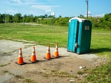
Ever since Roving Photojournalist LadyStyx captured the image that follows, I've been pondering its significance. I've stayed awake for hours on end, night after night, wondering, pondering and searching the web for answers to just what this picture means...


According to our photojournalist, the Green Flag Marks the Spot but... the spot of... just what?

Well, recently, my Mom joined the ranks of Roving Photojournalist and got this scene captured on digital film - and became OCHAShutterbugitis Patient number 100 plus. While I am distraught over her getting this seemingly incurable illness, it did provide an answer to just what the green flag in the picture is marking. It is so obvious to me now!


Rare OCHA Breed Seen in New Jersey

The green flags mark the spots of dead Green OCHAs! Its amazing how obvious some things are... in retrospect. However, now of course, we have a whole bunch of new questions, starting with what do we call green OCHAs? the GRECHAs? and what killed the one lying beneath the green flag? And if they live in New Jersey, how'd did the dead one get to where it finally rests? Are these actually a different species or is the pollution in New Jersey turning OCHAs green?

Sigh... I'll never sleep nights.

For those that are curious, the GRECHAs** belong to the Delaware River Joint Toll Bridge Commission and are located at the end of the Calhoun Street Bridge in Trenton New Jersey.


This bridge is one of three bridges connecting Trenton, New Jersey with Morrisville, Pennsylvania. Construction of the original bridge, known as the "City Bridge", began in 1859. It opened to traffic on July 1, 1861. The wooden bridge continued in service for 23 years until the evening of June 25, 1884, when disaster struck. The bridge was completely destroyed in one of the most spectacular fires ever witnessed in the area.

The "City Bridge" was replaced with an iron truss structure using the original stone masonry piers and abutments, undamaged by the fire. Built by the Phoenix Bridge Company of Phoenixville, Pennsylvania and opened to traffic on October 20, 1884, the bridge is the same structure standing on the site today.

Source

**provisional usage

Friday, May 16, 2008

Of Miles and Geese

As of May 16, 2008 at 7:00 AM
Steps: 2,943,728
Miles: 1229.71

Along the Schuylkill River Trail are goodly number of white obelisks and for a while, I've debated with myself as to whether these "items" might be aliens or not. At long last I have decided that, regretfully, they are not.


Mile Marker 20 / 75

The Schuylkill River Trail lies (mostly) on the former railroad bed of the Pennsylvania Railroad line that ran from Philadelphia into the coal mining areas of the Poconos. The railroad ran along side of the Schuylkill River through the cities and towns of Manayunk, Conshohoken, Norristown, Valley Forge, Phoenixville, Pottstown, Reading, Hamburg, Pottsville (the home of Yuengling beer) and finally on to Delano and Delano Junction.

The mile marker above originally indicated to the train engineers and conductors, that they are 20 miles from the Pennsylvania Railroad's Broad Street Station which was downtown in Philadelphia next to City Hall and 75 miles from Delano Junction.

There are plans afoot to extend the existing trail this entire length (and beyond!) for a trail of over 140 miles from end to end. Mile 20 is between Valley Forge and Norristown in a town called Port Indian.


Mile Marker 22 / 22?

This marker is located in the Valley Forge National Historic Park and could use some "freshening up". I don't know who does this, but a lot of these markers are re-painted pretty regularly.


Mile Marker 11 / 84

Maybe someday, I will have taken a picture of all of them and collected the entire set.


A Family of "Doze" Chin Strap Ducks

I walked past this family located at about Mile 9, along side the Manayunk Canal. Daddy Goose was most upset that I was anywhere near his little ones and put up quite a show of wing flapping, neck bobbing, and hissing. Mama Goose just scooted the little ones off the trail into the grass and let Daddy do all the "talking". I gave them wide berth and took their picture on the way by while watching for Goose Gifties under foot.


Manayunk Canal and Schuylkill River from the Air

I took this picture some years ago, while flying in an old WWII Army transport plane with my Dad. The Manayunk Canal starts just to the left of the water cascading over the dam near the bottom-left. The brown ribbon that runs along side the canal is the Schuylkill River Trail where I encountered the Geese in the previous picture. I might write more on Manayunk some other time.

Thursday, May 15, 2008

My New Membership Card


Card Proudly Placed in Wallet

If the "Commited T-shirts" I ordered come in soon, I'll model one for ya.

Insanity Supplied By Local Drinking Water
Graphic Supplied By LadyStyx

Mile 1214 - The City of Crisfield, MD

As of May 15, 2008 at 7:00 AM
Steps: 2,925,013
Miles: 1222.04

The Crab and Seafood Capital of the World


The Docks of Crisfield - Painting source

Crisfield is the southern-most town in the State of Maryland and has long been referred to as "The Crab Capital of the World."

For nearly three centuries the area now called "Crisfield" has been famous for its seafood - especially its Blue Crab and Oysters, its watermen, its natural beauty and its sense of community built on a common faith and deep roots.

Founded in 1666 by Benjamin Summers, Crisfield was originally known as Annemessex and the cove bordering Benjamin Summers' land was known as Somers Cove. Gradually the name of the village was changed to Somers Cove.

In 1854, a survey of the Chesapeake Bay discovered a large number of oyster beds in Tangier Sound adjacent to Somers Cove. John W. Crisfield recognized the importance of this natural resource and pushed the Eastern Shore Railroad from Salisbury to Crisfield.

With the advent of the railroad the products of the Chesapeake Bay could move from the Eastern Shore to the lucrative markets of the northeast. In recognition of his contributions to the city, the town fathers changed the name of the city from Somers Cove to Crisfield.

Source

The J. Millard Tawes Historical Museum houses artifacts depicting how seafood is harvested and processed and its model boat collections illustrate the types of water craft which plied the Bay. The museum also has assembled artifacts related to Lem and Steve Ward who are the acknowledged founders of the unique American art form of decoy carving and painting.

Source


Today, many tourist go to Crisfield to board boats to go to Smith and Tangier Islands. Such a trip is a trip back in time -


Smith Island


Tangier Island

With the turgid, muddy water they live in, one has to wonder how crabs end up tasting so good!