Wednesday, February 6, 2008

The Center of My Known Universe

As of February 6, 2008 at 7:50 AM
Steps: 1,160,818
Miles: 494.28
Miles to Georgia: 38.72


While I don't approve of the choice of "commuting vehicle", the picture on the fake licence plate made me stop to snap a picture. It says End - US Route 1 - Key West.

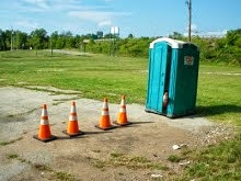
This "thing" was parked in a lot at Betzwood, next to the Schuykill River Bike Path and not far from the 10 foot in diameter Alien Spaceship Spheres.

So it's obviously a case of Real meets Virtual meets Alien worlds.

Tuesday, February 5, 2008

Mile 488 - Green Cove Springs

As of February 5, 2008 at 8:05 AM
Steps: 1,143,414
Miles: 486.87
Miles to Georgia: 46.13


The rich history of Green Cove Springs is tied to the natural springs and the St. Johns River. The area was first settled in the mid-1800s and was called White Sulfur Springs. After that and around 1850, Green Cove became a prime attraction, famous for the warm, therapeutic springs.


The spring is in the round well. The water flows from there directly into the swimming pool. I've had the delightful pleasure of swimming here with my brother, Mom and Dad on a fiercely hot day.

The sulfur springs brought wealthy visitors down the St. Johns River by steamboat to vacation at the grand hotels like the Clarendon and Qui-Si-Sana. Visitors of the period included Henry Flagler and his new bride, the Astors and Vanderbilts.

The spring is one of approximately a dozen sulfur water springs in Florida and is still popular today as a tourist site and a public swimming facility. The water boils up from a large fissure, some twenty feet below the surface at the rate of approximately 3,000 gallons per minute. The water is crystal clear.


Here we see a Banana tree thriving on the clear spring water.

The visitors drank from the spring believing in its medicinal values. It is said one local physician prescribed the spring water for various chronic ailments of the liver and kidneys. There are those today that still have confidence in the therapeutic value of the springs and can be seen daily drawing water from the spring for consumption.


The 78-degree spring feeds the municipal pool and then flows down Spring Run into the St. Johns River. The spring and pool are both located in beautiful Spring Park.


The spring water flows into the St. John's River near the site of the public dock. My Dad and I rode a dingy just past the end of this dock in an exploration trip of a creek formed by Magnolia Springs, just north of Green Cove Springs.

History and Facts Source


I had the good fortune to spend some time in the vicinity of Green Cove Springs. The first trip was to board a houseboat and motor it from here to Oxford, Maryland on the Chesapeake Bay. The second time, my parents and I spent a week motoring around in the Semper Fi, which we called the Big Red boat. Here I am in the Semper Fi's dingy, getting ready to explore one of the many creeks off the St. John's River.


My Mom and Dad wave to me from the Semper Fi. I will always remember both of these waterborne trips, they were both experiences of a lifetime.

Monday, February 4, 2008

Bottles in a Tree

Its about 3 days Virtual World Walking from Saint Augustine to Jacksonville.


If you click on the picture - you will see it is decorated with a lot of colored bottles. On sunny days like this one, it sparkles and casts rainbows.

I've no idea why the owner of the house did this though. I see this tree fairly regularly as it is along the route of my lunch time walk, which usually takes me to the Post Office.


Someone doesn't think too highly of the current crop of Presidential Candidates.

Sunday, February 3, 2008

Barren Hill - February 2, 2008

As of February 3, 2008 at 2:15 PM
Steps: 1,122,762
Miles: 478.06
Miles to Georgia: 54.94


The Schuylkill River Bike Path follows the river closely. It is just to the left in this picture in Spring Mill, PA. Barren Hill is straight ahead in the distance and Miquon is just around the bend in the river.

The City of Philadelphia line is about 3 miles from this point. Downtown Philadelphia (near the Art Museum that Rocky stood at) is about 15 miles down the path. On a nice day, it is a very interesting walk from here.


This old stone house was built in 1774. This house was here when Lafayette (why didn't they just call him Joey?) took his forces to Barren Hill.


The house in the previous picture is just off to the left in this picture of the old Pennsylvania Railroad bridge. The steel poles are uprights that used to hold up the electric wires that powered the trains. The railroad is long gone and is now the bike path. You can see a biker in blue near the center of the picture if you look hard. The creek flowing under the bridge is named Lafayette Creek. Barren Hill is in the distance over the rise. There was a railroad stop named Lafayette on the Pennsylvania Railroad right here in the 1890s.


A very short distance away is the Reading Railroad station. The bright yellow ten foot clearance sign marks the road bridge which is next to the bridge over the creek seen in the previous picture.

I usually walk down wind when it is cold. You see the flag blowing and it was chilly on the day I walked. The nice thing about the path is that it runs right next to the working railroad (now SEPTA) and you can park in a station lot (free on weekends), walk for miles downwind, catch a train someplace else and ride it back to your car.


Another nice thing is that on the other side of the tracks is the heated waiting room. No bathrooms here though, and none on the trains either.